Advancing Conservation with Satellite Imagery
Partners: Mara Elephant Project, Langland Conservation, Centre for Ecosystem Restoration Kenya, Geoxfinity and Airbus Foundation
Key Species: Giant Pangolin, African Elephant, Leopards, Lions and Indigenous trees
2023 Award Winners
The Connected Conservation Foundation and Airbus Foundation are awarding four runners-up as part of the Satellites for Biodiversity Award. The winners include Mara Elephant Project, Langland Conservation, Centre for Ecosystem Restoration Kenya and Geoxfinity.
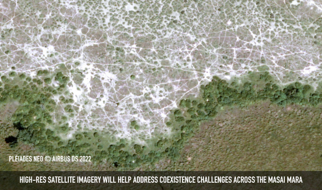
All organisations are working in the same ecosystem in Kenya on similar challenges, with similar satellite data requirements. By aligning requirements, we aim to establish a new collaborative initiative: The Masai Mara Satellite Sandbox.
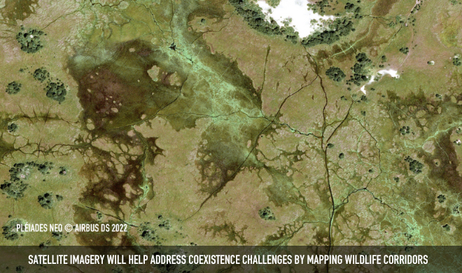
The Satellite Sandbox will accelerate the application of Earth Observation data and AI for conservation in the Masai Mara region and beyond. Combining the power of high-resolution satellite imagery, with local GeoSpatial and conservation expertise to monitor wildlife, habitat and landscape changes over space and time to address biodiversity, climate and coexistence challenges across the Masai Mara.
The data will help map many important aspects of this unique ecosystem, including settlements, agriculture, surface water, human infrastructure, forest and vegetation cover, fence lines, boundaries, invasive species and wildlife corridors. Having this holistic picture helps inform adaptive management for conservation projects and provides a baseline to measure progress.
Local conservation teams in Masai Mara, Kenya, will receive a 30 cm Pleiades Neo Mosaic, enabling them to advance their research and conservation efforts:
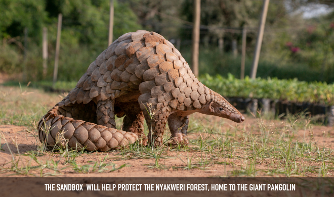
- Protecting the Giant Pangolin and Nyakweri Forest
- Safeguarding species and local livelihoods from the spread of invasive species
- Restoring Wildlife Corridors for Human-Wildlife Coexistence
- Plotting land boundaries to establish geo-fences that raise alerts when elephant trackers cross, to reduce human-wildlife conflict
With increasing accessibility to satellite data globally, the initiative aims to make learnings and insights from these projects available to the conservation community for wider benefits.
Runners up:
Protecting the Giant Pangolin and Nyakweri Forest, Langland Conservation Ltd
The Nyakweri forest, the cherished home of giant pangolins, faces imminent threats from deforestation, charcoal burning and the construction of electric fences. These activities are causing habitat fragmentation and pangolin deaths.
To combat this urgent issue, Langland Conservation is mapping current and historical land cover to provide concrete evidence of this deforestation and fragmentation. High-resolution imagery together with pangolin tracking data, will help the Pangolin Project team engage with high-level political stakeholders, raise awareness of the issues and guide decision-making for the protection of the giant pangolins and their habitat.
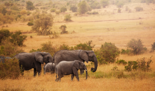
Safeguarding Elephant Habitat, Mara Elephant Project
The Maasai Mara faces multiple threats, including population growth, land fragmentation, deforestation, encroachment from human settlements, charcoal production, overgrazing and human-elephant conflicts. The space battle has intensified.
High-resolution satellite imagery will be used to map land cover and overlay real-time and historical movement data from satellite-collared elephants.
The layered information will help MEP keep communities and elephants safe and foster harmonious coexistence in the Maasai Mara.
Safeguarding species and local livelihoods from the spread of invasive species - Geoxfinity
This project focuses on safeguarding keystone species and local livelihoods in the Maasai Mara from the spread of invasive species. By utilizing high-resolution satellite imagery, Geoxfinity aims to map, model and predict the distribution of invasive species to help local teams control their spread and mitigate their impact on human health, food security and livelihoods.
The project includes a critical initial step of assessing the viability of detecting the invasive opuntia (prickly pear) tree from space in 30 cm imagery.
Restoring Wildlife Corridors for Human-Wildlife Coexistence - Centre for Ecosystem Restoration, Kenya
The peaceful coexistence between humans and wildlife is at risk from the removal of historical wildlife corridors and the degradation of critical ecosystem features caused by human activities.
Through earth observation data and machine learning models, the team aims to map and analyze the geographic and temporal patterns of land-use change. By identifying potential locations for wildlife corridors, the team aims to facilitate the re-establishment of vital connections within the ecosystem.
You can visit all of our 2023 Award winners here.