
Repairing a planet under pressure: six conservation projects awarded ultra-high-resolution satellite technology to help restore threatened ecosystems
The Connected Conservation Foundation (CCF) and the Airbus Foundation have selected six projects to receive support through the fourth Satellites for Biodiversity Award, giving practitioners access to state-of-the-art satellite imagery, advanced Earth Observation tools and technical expertise to detect threats, monitor change and contribute to the restoration of threatened ecosystems.
Published 30 June 2026
The winning projects span environments under intense pressure — from Indonesia’s rainforests, home to the world’s rarest great ape, to Patagonia’s fragile wetlands and the degraded Aral Sea bed, where toxic dust storms continue to affect communities, wildlife and ecosystems. These projects demonstrate how detailed insights from space, machine learning and community-led conservation can be combined to identify threats, guide restoration efforts and measure progress.
Each project will receive access to Airbus’ Pléiades and Pléiades Neo satellite imagery, including very-high-resolution (VHR) imagery at 30cm and enhanced Pléiades Neo HD15 imagery. This level of detail will enable conservation teams to analyse landscapes, track ecosystem change and target restoration efforts with greater precision than ever before. Technical support from CCF and complimentary ArcGIS Pro software from Esri will enhance mapping, monitoring and conservation planning. The three projects most in need of financial support will also receive $6,000 in funding, with all projects receiving technical support from CCF to help implement the projects.
“Human activities have transformed ecosystems at an unprecedented rate, leaving species and communities facing increasingly complex challenges,” says Sophie Maxwell, Executive Director of Connected Conservation Foundation. “But these landscapes are not beyond repair. By combining earth observation, Artificial Intelligence, local expertise and community leadership, we can help conservation teams understand what is changing, respond faster and support nature’s recovery.”
This fourth round of the award has been the most competitive to date, attracting close to 200 applications from 52 countries and territories. The breadth and quality of submissions have been unprecedented, spanning 85 species groups and 55 habitat and ecosystem types.
Congratulations to round 4 awardees:
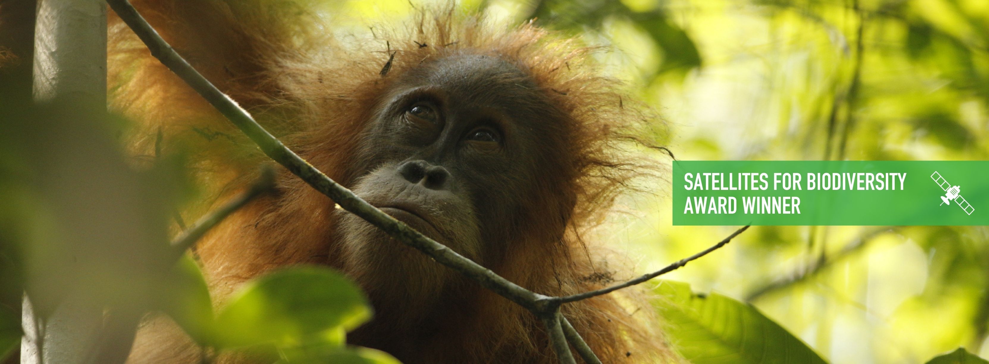
Yayasan Ekosistem Lestari (YEL): Rainforest deforestation resilience for the world’s rarest great ape – the Tapanuli orangutan, Batang Toru, Indonesia
The Tapanuli orangutan survives only in the forests of Batang Toru, where deforestation, habitat fragmentation, flooding and landslides threaten its remaining habitat. YEL will use 30 cm satellite imagery to monitor forest change, identify emerging threats and support restoration efforts to protect one of the planet’s most irreplaceable species.
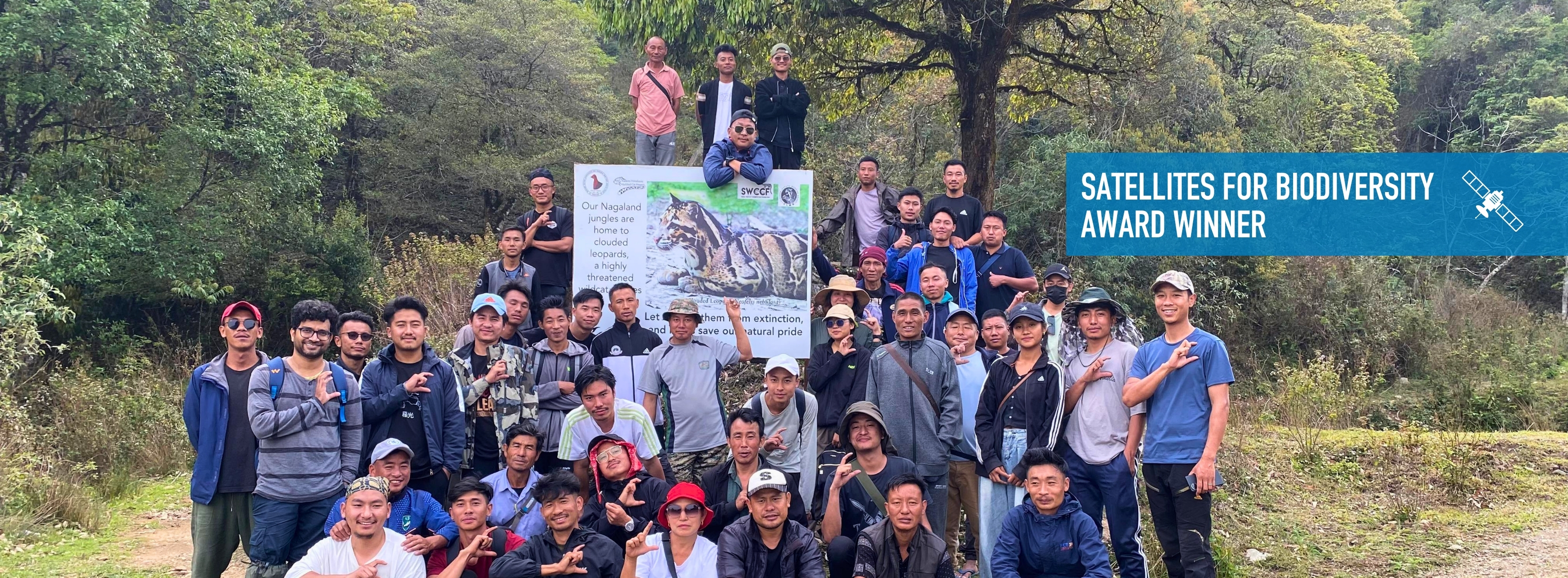
Fishing Cat Conservation Alliance: Connecting community-managed forests for clouded leopards — Nagaland, India
Across Nagaland’s community-managed forests, local communities are protecting landscapes that support clouded leopards and a rich diversity of wildlife. VHR satellite data will provide a high-detail view of forest conditions across fragmented landscapes, helping detect changes, map habitat connectivity, and guide sustainable landscape management — strengthening approaches where communities lead conservation action.
Nirvana Carbon Foundation & UN Sustainable Development Solutions Network: Healing the Aral Sea desert — Kazakhstan and Uzbekistan
The shrinking of the Aral Sea is one of the most significant examples of human-driven environmental degradation. The exposed seabed has created the Aralkum Desert, generating toxic dust storms that threaten communities, wildlife and fragile ecosystems. Using high-resolution Pléiades imagery, the teams will monitor large-scale restoration and re-greening efforts, including the planting of Black Saxaul and White Saxaul to stabilise soils, reduce dust emissions and restore habitat. The imagery will help measure progress over time and identify opportunities to accelerate ecological recovery across the landscape.
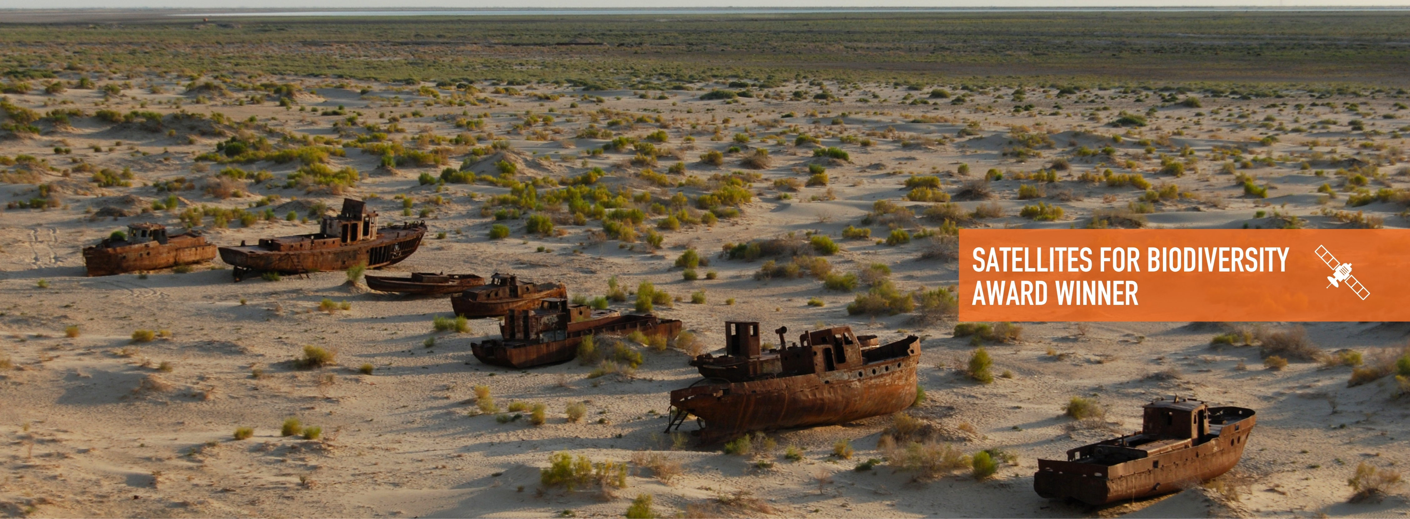
“The sub-metre resolution of Pléiades imagery gives us an unprecedented ability to monitor saxaul restoration across the Aralkum,” says Guilherme Iablonovski, Geospatial Data Specialist, UN Sustainable Development Solutions Network.
“By tracking individual shrubs and restoration outcomes at scale, we can generate the evidence needed to guide investment, inform policy and measure progress in one of the world’s most degraded landscapes.”
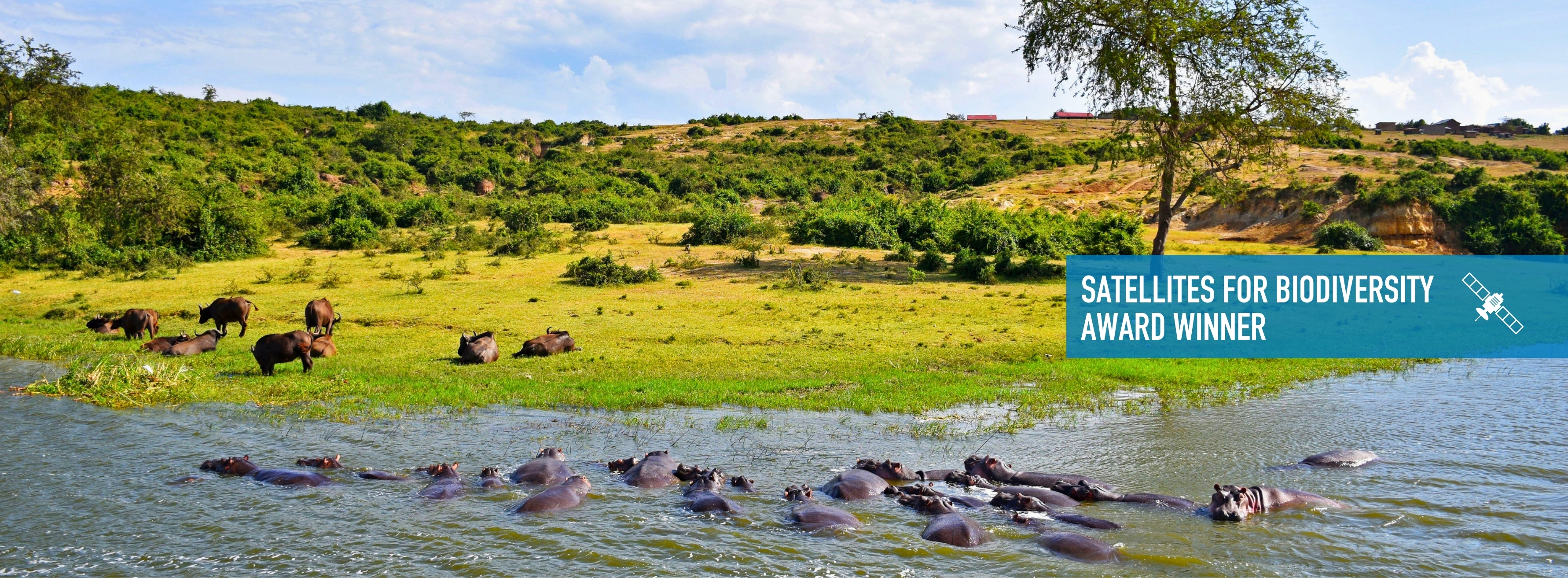
Uganda Conservation Foundation: Building resilient landscapes around Queen Elizabeth National Park — Uganda
Queen Elizabeth National Park is home to iconic wildlife, including its renowned tree-climbing lions, yet conserving this unique ecosystem depends on maintaining a delicate balance between people, livestock and wildlife. Using 30cm high-resolution satellite imagery, this project will provide detailed monitoring of the invasive sicklebush, cogon grass, carrot weed and wildlife movements — helping to target restoration efforts and strengthen coexistence across the landscape.
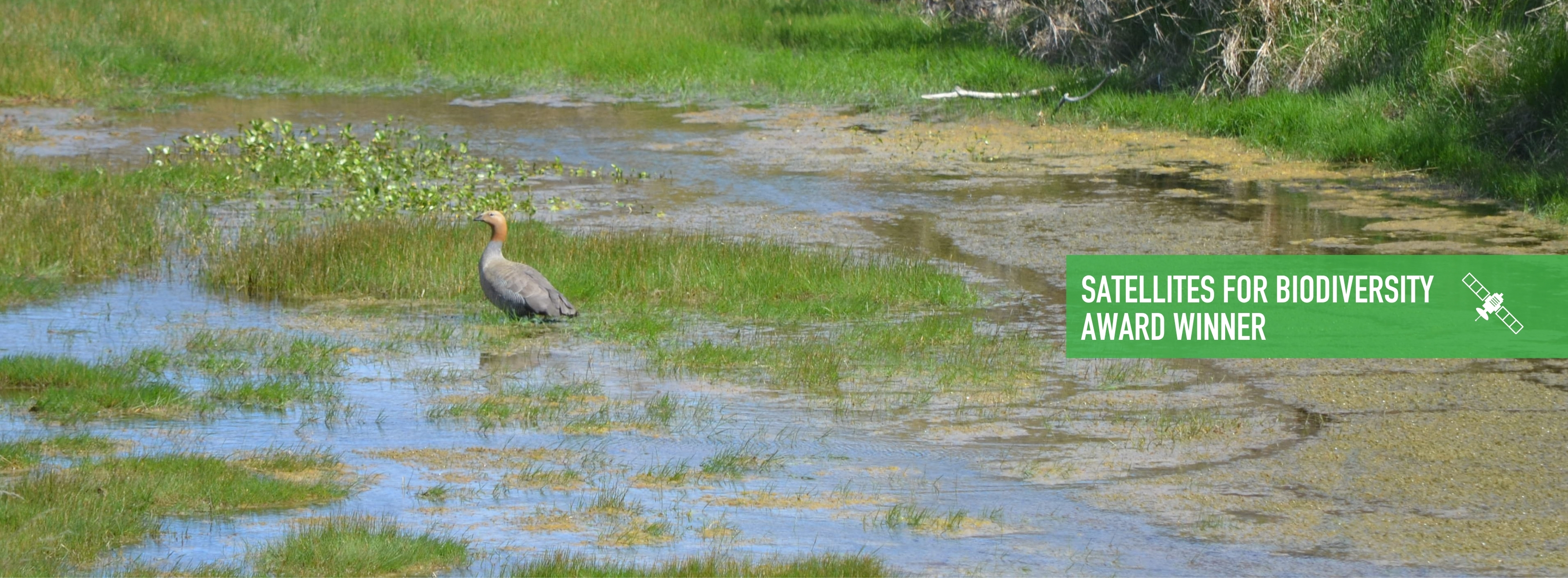
CONICET-UNComa: Recovering wetlands for the endangered ruddy-headed goose — Patagonia, Argentina and Chile
Patagonia’s wetlands provide critical breeding, feeding and refuge areas for the ruddy-headed goose, one of South America’s most threatened waterbirds. However, habitat degradation, changing land use, invasive predators, and historic threats such as poaching have reduced suitable habitat for the species. This project will combine VHR satellite imagery with field conservation measures, including artificial nesting islands, to map wetland conditions, identify restoration priorities and monitor ecosystem change — supporting targeted action and long-term protection for the ruddy-headed goose across Argentina and Chile.
A growing global partnership for biodiversity protection and recovery
Hania Tabet, Airbus Foundation Managing Director, said, “The environmental challenges these projects address are urgent and complex. Through our partnership with the Connected Conservation Foundation, we are pleased to support these conservation leaders by providing the satellite imagery, tools, and technical expertise necessary to better understand change, target action, and track impact.”
“We are particularly encouraged by the potential of these initiatives to be replicated and scaled for wider impact. These projects meaningfully demonstrate how Earth Observation can help turn knowledge into effective, restorative action for nature and the communities that depend on it.”
Since its launch in 2022, the Satellites for Biodiversity Award has supported conservation practitioners worldwide by providing access to advanced Earth observation technology, technical expertise and collaborative learning. Through open sharing of data, methods and lessons via The Ecosystem Insight Hub, the award helps accelerate scalable solutions for biodiversity conservation and ecosystem recovery.
ENDS
For media interviews, please contact:
Connected Conservation Foundation
Emma Oldham / Communications and Press Manager (07939180489) emma.oldham@connectedconservation.foundation
Airbus Foundation
Camila Orozco / Press Relations Airbus Foundation (0607542296)
maria-camila.orozco-quintero@airbus.com
NOTES TO EDITORS:
About Airbus Foundation
The Airbus Foundation provides access to Airbus’ unique portfolio of high-tech products, services and know-how to help address some of the world’s most pressing problems, developing impactful partnerships with NGOs and associations around the world to deliver its missions.
About Connected Conservation Foundation (CCF)
With urgency, CCF is equipping local conservation partners with cutting-edge technologies and training to save nature together with partners. Enabling landscape-scale solutions for an effective, well-connected system of protected areas, CCF is helping countries work towards safeguarding 30% of their lands by 2030. Through the digital transformation of conservation, CCF is supporting new ways to monitor, value and protect wildlife and wildlands.
About Esri
Esri was founded on the vision that geographic thinking and digital mapping could help design a better world. To this day, we remain passionately true to that vision, working closely with charities, government and commercial organisations across the world, to help them sustainably improve the lives of citizens, realise the potential of their communities and protect and nurture the environment for future generations. Our technology, ArcGIS and services make sense of complexity and model the world from a geographic perspective that recognises the importance of place in improving people’s lives.